

By Amy Rieffer, Conservation Education Intern –

Imagine yourself floating on a river; you leisurely paddle along when you suddenly spot a bald eagle soaring overhead. You can feel the sun warm your neck and you begin to hear the trickle of a creek entering the river up ahead. Canoeing is a wonderful activity for all ages and skill levels. If you have never gone canoeing before, go with someone who can teach you. A canoeing trip can be quiet and relaxing, but it can also be intense and a great way to work out.
Always plan your canoe trips ahead of time. Know where you are getting in and out of the river and how long the trip should take. Most paddlers make 2 to 3 miles per hour with steady paddling. Factors such as water level, wind, paddling effort, and stops for lunch, fishing, or wildlife watching will affect float times.
Be aware of potential hazards and know how to handle them. Avoid fallen trees, look out for large rocks and always portage around lowhead dams. Make sure to wear a life jacket, quick-drying clothes and sun protection. Put items such as snacks, cameras and binoculars in a waterproof bag because water will likely get in the canoe at some point. Even if you handle the rapids perfectly, you will probably have to get out and push the canoe along in shallow water.
Fall is the perfect time for beginners to float rivers. The water usually isn’t too high, the leaves start changing color and you may see migrating birds. There are two rivers in Cerro Gordo County to canoe: the Shellrock River and the Winnebago River.
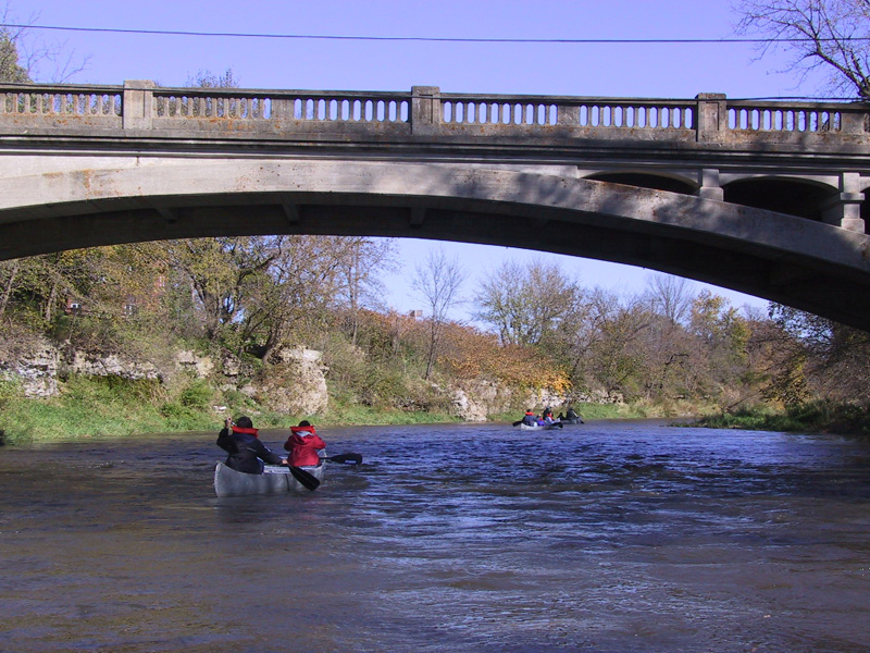
The Shellrock River offers a fun outing with some fast ledge rapids. If you are looking for a little thrill, three of the ledges are class 2 whitewater rapids at high water levels. The Shellrock River takes you by the arched bridge in Rock Falls and abandoned trestle bridge. This is a very scenic paddle with the bonus of whitewater. The Shellrock River flows roughly north and south for 11 miles in Cerro Gordo County from Plymouth to Nora Springs. There are three county access points and two camping areas along this stretch.
The Winnebago River offers the canoeist a pleasant paddle lined by limestone cliffs and wooded areas. Cerro Gordo County is home to 33 miles of the Winnebago River. The river runs across the county from west to east with seven county access points and one primitive camping area along the Winnebago. The varying distances between access points allows for long and short excursions. Excitement lies downstream between Averydale Access and Claybanks Forest. There you can find the fiercest rapid on our stretch of the river, a cave to explore and a place to hunt for fossilized sea creatures from the Devonian era when Iowa was underwater.
Canoeing a river can be challenging for beginners, so if you would like a more relaxing day of canoeing you can check out Cerro Gordo County’s wetlands. County owned wetlands include Mallard Marsh, Zirbel Slough, Mike Zack Wildlife Area, Quarry Lake and Bluebill Wildlife Area. Canoeing rivers and wetlands is part of the Recreational Experiences Close to Home series which highlights outdoor activities that can be enjoyed on Cerro Gordo County Conservation Board areas. To get more information about canoeing local areas pick up a brochure at Lime Creek Nature Center or visit our webpage at www.co.cerro-gordo.ia.us, look under Conservation and click on Recreational Experiences Close to Home. Get outside, canoe and have fun.
Shellrock River Access Distances
Strand Park to Wilkinson Park= 5.5 miles
Wilkinson to Shellrock River Greenbelt= 5.5 miles
Winnebago River Access Distances
Kuhn Wildlife Area to Winnebago Oxbow= 2 miles
Winnebago Oxbow to Kingfisher Hollow= 9.5 miles
Kingfisher Hollow to Spring Creek Preserve= 6 miles
Spring Creek Preserve to Lime Creek Conservation Area= 2 miles
Lime Creek Conservation Area to Averydale Access= 4 miles
Averydale Access to Claybanks Forest= 6 miles