


Although snowpack melting is not expected to cause significant flooding in the Missouri River basin, annual runoff is expected to be 170 percent higher than normal, enhancing the risk for flooding in the eastern part of the basin.
“We are entering the three rainiest months, so wet conditions could continue,” said Tim Hall, DNR’s coordinator of hydrology resources. “There is lots of water in the soil and groundwater which could result in flash flooding.
“Iowans should monitor conditions carefully in the months ahead,” he added.
Streamflows in the interior streams have dropped from March levels except in northwest Iowa where they are still above normal or much above normal.
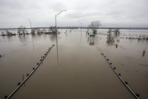
Major flooding has occurred along the Mississippi River, especially south of Dubuque. Davenport set a preliminary, but not official, record high flood crest of 22.7 feet on May 2. The previous crest of 22.63 feet was set July 9 in 1993.
Preliminary statewide precipitation in April totaled 2.96 inches or 0.55 inches below average, with a wide variation in local levels. In Montgomery County, rainfall in Red Oak was 2.61 inches below average for the month. While in Clinton County, the city of Clinton received 3.12 inches above average.
![]()
For a thorough review of Iowa’s water resource trends, go to http://www.iowadnr.gov/watersummaryupdate.
The report is prepared by technical staff from Iowa DNR, the Iowa Department of Agriculture and Land Stewardship, IIHR—Hydroscience and Engineering, and the U.S. Geological Survey, in collaboration with Iowa Homeland Security and Emergency Management Department.