
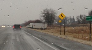
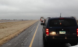
AMES, Iowa – Jan. 27, 2013; 11:05 a.m. update – Northbound Interstate 35 in Franklin County near milepost 164 is currently blocked. There is a significant back-up of traffic in this area and delays can be expected. Avoid the area if possible.
Semi-tractor-trailer units are having difficulty negotiating the roadway grade at this location. Iowa Department of Transportation road maintenance crews are in the process of returning to their stockpiles to get more salt loaded on their trucks and then will immediately return to this area to help get traffic moving again. We ask for the public’s patience as travel to and from the site is treacherous and will take some time on the part of maintenance crews.
North central and east central Iowa are currently experiencing the brunt of the ice storm. Travel is also very slow between Algona and Spencer on U.S. 18 as the precipitation lingers along the Iowa-Minnesota border. Pavement and air temperatures remain at or below the freezing level in these regions.
The National Weather Service in Des Moines is reporting the winter storm warning will continue through Sunday.
Abundant moisture and warmth aloft will push into Iowa today ahead of a low pressure system in Kansas. Freezing rain and some sleet will continue across Iowa this morning and persist across North and Northeast Iowa into this evening.
Winter Storm Warning remains in effect until midnight CST tonight.
- Timing trends, intermittent freezing rain, mixed at times with sleet, will continue into the afternoon before tapering off during the evening hours.
- Storm total ice accumulations, ice accumulations up to one quarter inch are expected. Although sleet may occur across far northern Iowa at times, any accumulations should be minor if at all.
- Winds/visibility: winds will be Southeast at 10 to 20 mph. However, significant visibility restrictions are not anticipated.
- Impacts: Many road surfaces and walkways will remain ice covered and very slick in spots as surface temperatures remain around the freezing Mark through much of the day. In addition to the road surfaces, the ice accumulation may begin to bring down branches and power lines by Sunday afternoon resulting in some power outages. Travel is not recommended in the Waterloo and Cedar Falls areas.


I seen that Semi in the ditch just north of the Kum and Go at the Ellsworth exit followed by a 5th wheel camper on it’s side.